
Inca Trail to Machu Picchu
Day 14: start of the Inca Trail. The Inca Trail is the name of a journey through the mountains to Machu Picchu, a holy Inca city. Sure is that the Inca's used this route because of the part that is paved. Machu Picchu was discovered in 1911 by the American Hiriam Bingham. It's also known as the "lost town". This because the Spanish have never been able to find this city so it couldn't be destroyed also by them. The Inca's didn't use any writing, only counting by using abacuses and painting so that's why there's not much known about Machu Picchu. It was probably a holy city where the king lived but an other story says there lived a select group of young virgins to honor the gods. Why Machu Picchu was deserted by the Inca's is unknown.
We left from Cuzco by bus and stopped first at Olllantaytambo. This is another holy temple by the Inca's and like Machu Picchu and some other temples situated in the valley of the river Urumbamba. In Spanish this valley is called "valle sagrado" (holy valley). After visiting this temple we went along and at km. 78 we started walking. Normally people start the trail at km.88 because there's a little train station there.
The first day was easy, "Peruvian flat". We started at an height of 2700 mtrs and walked 11 km until Llactapata at 2788 mtr. This was a fortress that had to protect the entrance to Machu Picchu probably because not everybody was allowed to go to Machu Picchu. In these mountains you see sometimes condors flying, they're rare but we had the luck to see one already the first day. A little bit disappointing was that it started to rain in the afternoon, but no complaints because the weather was great during the rest of the trip.
Llactapata
The second day of the trip we went up until 3680 mtr at Llucha-pampa about 500 mtr under the "dead woman's pass" that is with 4200 mtr (13773 ft) the highest point of the trail. The distance we walked on the second day was 10 km. Only the last few km were heavy because of the altitude and some steep slopes. Then we noticed how important it is to get a decent preparation. Because we stayed already some days on altitude in Puno most of us didn't have any problems with the altitude. It seems that there're still some people who fly from Lima directly to Cuzco and start the trail one or two days later. These are the people who'll get sick easy. Acute Mountain Sickness (AMS) can be deadly when not recognized and treated on the time. You have to have some talent for getting it but risks are lower by a decent preparation. Normally ams occurs only at altitudes above 4000 mtr. At these heights it can get cold at night and we noticed it. That night the temperature dropped until about 0C.
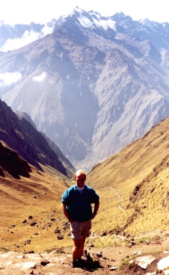
up to Dead Woman's pass
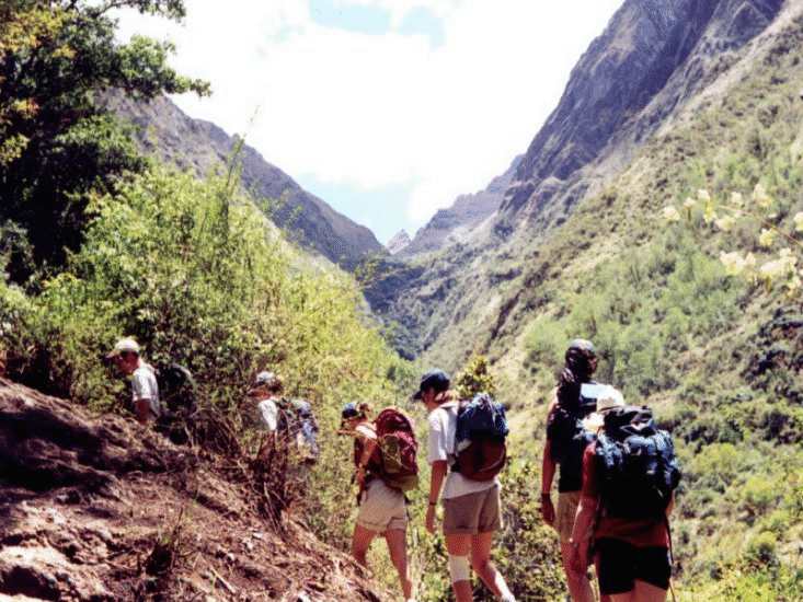
On this picture you see that we're not carrying much. We had an organized trip with porters, cook and tents supplied. I must say it made me feel very rich but on the other hand that made it easier also and gave us more opportunities to enjoy everything. When you do go on an organized trip don't cut back on it because it will mean they're underpaying the porters, supply you with lousy food and that's not worth it.
The next day we left at 7.30 AM and had to do the toughest piece of the trail right away. The 500 mtr climbing and 2 km walking took about 2 hours. After the pass it went down steep and it was about 4 km descending to 3700 mtr. After that the paved part of the Inca Trail started. Paved trail means a lot of stones but still a lot of climbing and descending. The Inca's made about 25000 km of paths in their empire where most of these paths were paved.
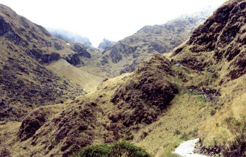
Dead Woman's pass seen from two sides
On this day there was an annual event from Cuzco on the trail. They had organized a marathon along the trail. They start at km 88 and do the whole trail in a little bit more than 4 hours !! When we were struggling to go up they ran past us like we were standing still. After the descent it went up ofcourse like everytime in the mountains. First thing we met was the temple of "Runkuraqay" along the route. This one and some other temples can only be reached by foot. After that it went up further until 4000 mtr, the top of the second pass.
Especially the second and the third day the views were magnificent. Everywhere around you, you see green mountains. Because of the proximity of the equator it's never really cold and the treeline is much higher than for example in the alps. I estimate it to be around 3500 mtr. After the second pass we descended again until 3728 mtr near the ruin of "Sajamarca". From here it went up a little bit and we stopped near the temple of "Phuyupatamarca". Here we spent the night just above the temple on a ridge at an altitude of 3700 mtr. The distance we walked this day was 16 km and it was the hardest day but I must say with a reasonable condition the trail can be walked without problems although it shouldn't be underestimated.
Every year thousands of people walk the trail. The busiest part of the tourist season is december, january. In the mountains we met almost nobody. Halfway the second day we passed the last place where people live. Travelling with a group is better in the mountains because it's really lonely and there are reports from robberies over there.

view on some mountains
The last day consisted mostly of descending to Machu Picchu. The first view on Machu Picchu we had after a few hours. In the beginning of September there was quite a big fire in the forests on the mountains surrounding Machu Picchu. The damage was enormous as you can see on the picture below. The fire came to the edge of Machu Picchu and it would have been a disaster if it had destroyed this unique monument. Cause of the fire was probably a farmer that burned his land in order to get fertile land.

Surroundings of Machu Picchu, brown pieces are burned,
Machu Picchu on the right side between the first two mountains
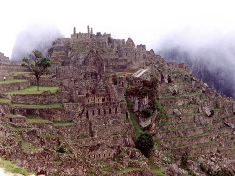
Through "Huinay Huayna" an other Inca-site and a lot of forest we arrived in the early afternoon at "Iti Punku" (gate of the sun). After a short steep climb you're confronted with Machu Picchu. Here at a distance from 1 km and 100 mtr higher there's a magnificent view on Machu Picchu. After having lunch here we completed the last piece of the Inca Trail. Eventually we were at an altitude of 2460 mtr in Machu Picchu.

Machu Picchu in the afternoon
We arrived around 3 PM in Machu Picchu. At that time of the day it was really quiet there and that are the greatest moments to go to Macchu Picchu and enjoy the views. The buildings and surroundings can put a spell on you if it's quiet like that. At the bottom of mountain lies the village Aguas Calientas. Here you can come by train from Cuzco. Once a day a train goes and brings 6 to 700 tourists, all with clean clothes, hats so white they hurt your eyes and some ladies even on high heels. After 4 days without interruptions spend in the mountains, without showering, shaving and without any clean clothes this confrontation with the civilized world is enormous.

Machu Picchu in the morning
The night we spent at the camping site in Aguas Calientas. That evening we went to the hot water springs there and could finally wash ourselves again and important was as truly western, civilized people we could buy liquor again and drink it ofcourse. The next day we went back to Macchu Picchu 7.30 AM to see it again when it's peacefully. Our tourleader was a Peruvian guy and gave us a detailed explanation about what is known about Macchu Picchu. At about 10.30 the tourist buses arrived and that was the end of the spell unfortunately.
In the afternoon we took the train back to Cuzco. The next day was free and we used it to visit some other museums in Cuzco and in the afternoon I went to Pisac with some other people of the group. Pisac is a little village with a well known art market and at about 600 mtr above the village there's a Inca-site with some fortresses. This site is in reasonable state but compared to Machu Picchu it was a little bit disappointing. We should have visited it before we went to Machu Picchu.
Day 20: plane back to Lima.In the afternoon I went to the national museum where they have the most complete exhibition about the history and development of Peru. Besides that there was a special exhibition, called Siphan. This was about the lord of Siphan whose tomb was found completely intact. This tomb was filled with a lot of gold artifacts, an intact mummy and a lot of golden pieces of cloth and armor.
Unfortunately this was the end of a great time in a very beautiful country. The trip was very well organized, hotels were better than expected so I can recommend this trip to everybody. Next holiday will be in South America again and I will probably go to Ecuador or Nicaragua. Anybody who wants to join me, let me know!
The end
Last changed: 20-10-98
© 1998: Jeroen
promo
(Remove the
x in order to email)